Showing posts with label GNSS. Show all posts

Sokkia GRX3 Gnss Receiver


Positioning made easy

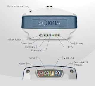
This fully integrated all-in-view constellation RTK GNSS receiver brings a new level of versatility and flexibility into your precision positioning applications. The GRX3 provides unmatched usability and versatility that’s sure to enhance your productivity.

  • And like all Sokkia products, you can customize it to meet your needs and create your own workflows.
  • Sokkia Tilt Technology
  • L Band Ready Technology
  • 226 Universal Tracking Channels™ covering all modernized signals (GPS, GLONASS, Galileo, BeiDou, IRNSS, QZSS, SBAS)
  • Integrated 400MHz UHF and SiteComm™ Radios
  • RTK and static survey operations
  • Fusion Positioning™ technology automated workflow
  • Standard RTK and Network RTK
  • IP67 rated


Sokkia Tilt Technology

The Sokkia GRX3 incorporates a revolutionary 9-axis inertial measurement unit (IMU) and an ultra-compact 3-axis eCompass. This advanced technology compensates for mis-leveled field measurements out of plumb by as much as 15 degrees. Awkward shots on steep slopes or hard to reach spots are now a breeze with tilt technology.

Open Architecture

The GRX3 architecture is designed so that third parties can write their own applications.

All Constellation Support

Featuring 226 Universal Tracking Channels with Universal Tracking Technology, the GRX3 has you covered. With programmable channels for tracking available signals, the GRX3 supports all modernized signals.

 Multiple Wireless Technologies

The most commonly used wireless technologies can be integrated into the GRX3 receiver. Digital UHF, Network RTK and SiteComm™.

 Maximum Versatility

Utilizing full wireless connectivity and no voice feedback, the GRX3 enables the use of both RTK and network RTK technologies. It can be operated as both a private RTK base and RTK rover using the internal digital UHF.

 Stay in Control

The GRX3 includes built-in internal Bluetooth®  capability that allows you to choose your field controller model and software. Whether it is a small palm-sized screen device, a larger screen handheld, or even a field laptop, the GRX3 is ready to connect.

 Ready for the field

The GRX3’s magnesium alloy body can handle even the toughest job site conditions. It’s compact, watertight, and rugged with IP67 rated dust and water protection.

GeoPro Software

This is the simplest, most effective software suite for the geomatics and survey professional.

 GeoPro Field

Welcome to the quickest and easiest way to collect and layout points in the field. GeoPro Field’s user friendly interface and simple but powerful controls help you work faster and more precisely.

  • Graphical interface available on Windows®  tablets
  • Collect field measurements
  • Control GNSS and robotic systems from Sokkia
  • CAD in the field functionality
  • Export point files to 3rd party software


 GeoPro Office

Process field measurement data from a variety of sensors in the same job file.

By combining data from multiple sensors, you get a more complete view of the project than you would with separate static files from each sensor.

  • Process raw data from field measurements
  • Work with total station, digital level, and GNSS receiver data
  • GNSS post-processing
  • 3D CAD view (optional module)
  • Road design tools (optional module)


Leica GS18 T GNSS RTK

Leica GS18 T – The world’s fastest GNSS RTK rover

Introducing the world’s fastest and easiest-to-use GNSS RTK rover, the Leica GS18 T. Now you can measure any point faster and easier without the need to hold the pole vertical.

This latest innovation combines GNSS and inertial measurement unit (IMU) being the first true tilt compensation solution that is immune to magnetic disturbances and is calibration-free. The GS18 T works directly out of the box.

Save up to 20 per cent over conventional surveying practices due to the fact that no time is wasted by levelling the bubble.Focus on your surroundings and not the bubble to measure points that previously could not be measured. Avoid timeconsuming auxiliary methods with true tilt compensated surveying. You will stake out more efficiently and conveniently than ever before with increased speed, safety and comfort. Watching the bubble is simply no longer needed.

The GS18 T GNSS RTK rover is part of the Leica Geosystems self-learning GNSS series. It seamlessly combines with Leica Captivate field software and Leica Infinity office software, continuing the powerful and immersive Leica Captivate Experience.


Engaging software

The Leica GS18 T is accompanied with the revolutionary Captivate software, turning complex data into
the most realistic and workable 3D models. With easy-to-use apps and familiar touch technology, all forms of measured and design data can be viewed in all dimensions. Leica Captivate spans industries and applications with little more than a simple swipe, regardless of whether you work with GNSS, total stations or both.

Seamlessly share data among all your instruments

Leica Infinity imports and combines data from your GNSS RTK rover, total station and level instruments for one final and accurate result. Processing has never been made easier when all your
instruments work in tandem to produce precise and actionable information.


ACC

Customer care only a click away Through Active Customer Care (ACC), a global network of  experienced professionals is only a click away to expertly guide you through any challenge. Eliminate delays with superior technical service, finish jobs faster and avoid costly site revisits with excellent consultancy support. Control your costs with a tailored Customer Care Package (CCP), giving you peace of mind you are covered anywhere, anytime.


TILT COMPENSATION

■■ Increased measurement productivity and traceability
■■ Calibration-free
■■ Immune to magnetic disturbances
■■ Integrated quality assurance of pole tilt
■■ Reduction of human error

RTKplus

■■ 555 channels for more signals, faster acquisition and
improved sensitivity
■■ Intelligent management of multi-frequency, multiconstellation
signals
■■ Intelligent selection to automatically reject reflected or
noisy signals

SMARTLINK
■■ Achieve centimetre accurate positioning worldwide -
perfect when working in remote areas around the globe

SMARTCHECK
■■ Unique RTK technology provides continuous checks to
guarantee correct results
■■ Initialisation within seconds
■■ Complete reliability

BUILT FOR THE MOST DEMANDING ENVIRONMENTS
■■ IP66 / IP68 protection
■■ Built for extreme temperatures of -40°C to +65°C
■■ Fulfils toughest standards throughout the complete
product lifetime
■■ Rugged aluminium housing

ERGONOMICS
■■ Integrated 4G mobile phone, UHF radio RTK devices
■■ Compact housing

ONLINE SERVICES
■■ HxGN SmartNet Satellite Positioning - your No.1
partner for network RTK
■■ Leica Active Assist - the next level in support
■■ Leica Exchange - transfer data easily, quickly and safely

This information is taken http://www.leica-geosystems.com

GeoMax X-Pole

GeoMax X-Pole

 When TPS meets


 GNSS WORKING SIMULTANEOUSLY WITH TPS AND GNSS

  By combining the advantages of both systems, the new GeoMax X-Pole solution significantly improves performance and flexibility on the jobsite. The seamless integration of X-Pole into the X-PAD field software allows a toggle between both measurement modes. Simply decide with the press of a button if you want to change from TPS to GNSS mode, such as when some points cannot be measured with TPS due to limited prism visibility. Once those points are measured, switch back to TPS mode.


 This enhances the efficiency of the system since it eliminates the need for cumbersome and time consuming station setups. Zoom70/90`s Track360 functionality enables following a moving prism. In case of loss of lock, the X-Pole solution immediately finds the pole position by obtaining the coordinates from the GNSS receiver mounted on top of the prism.

 KEY FEATURES
 • Simultaneous TPS and GNSS measurements during setup
 • Change from TPS to GNSS measurement mode at the press of a button
 • TPS and GNSS measurements stored in one common database
 • Modular solution to be combined with any GeoMax GNSS receiver
 • Flexible upgrade path even for robotic TPS and GNSS systems

Leica Viva GS16

Leica Viva GS16
Be Captivated

Leica Viva GS16 – Experience Innovation

Meet the latest innovation, a self-learning GNSS with RTKplus and SmartLink. The growing number of signals from an ever increasing satellite constellation demands a GNSS receiver to be smarter than ever before.

TOPCON Hybrid Robotic System

Integrated GNSS and Total Station


• GNSS and Optical Rover
• Auto-tracking of Prism
• Network or Local RTK
• LongLink™ Communication
• Rugged, Waterproof Design
• Improved Data Workflow

Hybrid Robotic System Software – Hardware – Technology

The most advanced productivity enhancing, integrated GNSS and robotic total station system, in a never before seen small design.

Topcon’s commitment to automating data workflows and increasing your productivity can be seen in this latest system of combined technology. Topcon’s slogan of “Your Productivity, Our Technology” is our commitment to providing industry leading productivity systems based on software, hardware, and technology. Systems that improve the way you work.

Zenith25 Pro Series

Equipped with the most advanced GNSS receiver technology, Zenith25 Pro delivers ultimate performance. Even in extreme environments the reliable, robust GNSS system “works when you do”.


Extremely rugged 

• IP68 dust and waterproof

• Withstands a 2 m drop

• Vibration resistant


Sokkia GCX2 Innovative GNSS Receiver

  • Dual frequency and multi-constellation GNSS RTK receiver 
  • Compact, lightweight, rugged, and cable-free design 
  • Bluetooth® and interference-free Data communication 
  • Simplified user display 
  • Precision Orbital Satellite Technology 
  • 226 Channels with optimized satellite tracking technology


Innovative Technology and Design

Innovative. Simple. Lightweight. Rugged.

The Sokkia GCX2 is a dual frequency GNSS receiver which delivers RTK (Real Time Kinematic) centimeter level performance in an innovative form. The GCX2 exemplifies a completely reimagined approach to receiver design that offers an ultra-lightweight and ergonomic solution at a low cost. 

South Galaxy G1

       SOUTH Galaxy G1, new generation integrated RTK system with smaller size and innovative design, leads the direction of new generation RTK with excellent performance, provides high-efficiency and intelligent surveying experience to customers. It isn't simply smaller, it's better in everywhere.

STANDARD SET 

Satlab SL 500

Multi Constellation Tracking 

Fully compatible to all the GNSS constellations available with onboard 220 channels. It can track GPS, GLONASS, GALILEO satellite constellations as well as SBAS satellites. This is futureproof equipment!

Seamless Operation in CORS Networks 

Since VRS is native technology, it works perfectly with corrections from CORS networks in any versions of CMR or RTCM without needing to interpret the message but reading seamlessly. No need to check wrong fixes due to wrong interpretation anymore.

Pentax G3100 - R1

Precision
Satellite Surveying
With Wireless Communications
G3100-R1
GPS | GLONASS


FEATURES
  • Single, rugged housing with all components for field survey and stake out
  • State of the Art 136-channel AsteRx2e receiver with GPS and GLONASS
  • Integrated satellite antenna for optimized satellite tracking
  • Base or Rover configuration for standard equipment use
  • Internal GSM Modem for connection to Real Time Networks

Satlab SL600 GNSS Receiver

Satlab SL600 6G GNSS Receiver

The Ultimate On The Pole GNSS System With 6G Tracking


All in one, on the pole GNSS Receiver

Intelligent System

Trimble GNSS Surveying Systems

TRIMBLE GNSS SYSTEMS: SOLVING YOUR CHALLENGES IN THE FIELD

INDUSTRY-LEADING GNSS SOLUTIONS DESIGNED WITH THE SURVEYOR IN MIND

Backed by a legacy of GNSS technology and surveying expertise, Trimble provides surveyors with reliable GNSS survey solutions that meet their distinct requirements. For more than 30 years, Trimble
has been setting the standard when it comes to positioning technology—and that tradition continues today and into the future.


Topcon GR-5 Advanced GNSS Receiver


• 216 Universal Tracking Channels

• G3 Tracking Technology (GPS/GLONASS/Galileo)

• Advanced Fence Antenna™ Technology

• High accuracy RTK up to 100Hz

• Integrated dual radio and cellular combinations


The GR-5 is the most advanced RTK GPS system from Topcon. This exciting system incorporates G3 tracking technology to track all three satellite positioning systems as well as new design features not found in any other system.

Topcon’s G3 technology was the first to combine all three of the original positioning systems – GPS, GLONASS, and Galileo. Although commercial use of Galileo continues to be years away, Topcon continues its commitment to develop technology to utilize ALL signals from ALL satellites. Not only is Topcon committed to the GPS, GLONASS and Galileo satellite systems, but also to all precision signals from the developing Chinese COMPASS system, Japan’s Quasi-Zenith Satellite System (QZSS), and India’s IRNSS system. If there is any operational advantage of combining new systems and signals, you can count on Topcon to continue to lead the industry. 

Sokkia GRX2 GNSS Receiver

Sokkia GRX2 has been enhanced with the latest GNSS chipset technology, providing 226 channels
and superior antenna quality. Both RTK and Static operations will be completed with increased productivity. The GRX2 provides unmatched usability and versatility that guarantees to increase productivity.


GRX2 GNSS Receiver

The GRX2 receiver is a fully integrated dual constellation receiver, antenna, radio, and optional cellular modem. In addition, the integrated Bluetooth® module, now enhanced for better performance, is designed into a rugged magnesium alloy body.

Fully Scalable Architecture