Showing posts with label Total Station. Show all posts

Leica FlexLine TS10 Manual Total Station

 LEICA FLEXLINE TS10 MANUAL TOTAL STATION 

Work faster: 
  • Measure more points per day due to faster measurements and stakeout procedures, supported by the revolutionary Leica Captivate field software. The software is made to make your work easier and more enjoyable.
Use it trouble-free: 
  • Increase productivity and minimise downtime by relying on instruments that simply work and come with a global service and support network.


Choose products that are built to last: 
  • Even after years of use under harsh conditions (like mud, dust, blowing rain, extreme heat and cold), FlexLine still operates with the same high level of quality. 
Control your investment: 
  • Reliability, speed and accuracy ensure a lower investment over the product lifetime and a higher resell value.
Save time with AutoHeight: 

  • This revolutionary feature enables the FlexLine TS10 manual total station to automatically measure, read and set the instrument height. Errors are minimised and the setup process onsite is faster.


The Leica FlexLine TS10 manual total station combines user-friendly, ergonomic design with high-end reliability under harsh conditions. It enables you to tie into the modern 3D dataflow, including enhanced linework and coding. The TS10 offers mobile data device integration as an option. The larger, highly visible colour- and touchscreen helps you to complete your surveying tasks with the highest speed and accuracy. The new FlexLine generation of manual total stations relies on a proven product concept that has been revolutionising the world of measurement and survey for nearly 200 years.

This information is taken http://www.leica-geosystems.com

Current selling price 35.000 $


    Trimble SX12 Scanning Total Station


    KEY FEATURES

    Trimble® SX12 is the one instrument you need to handle any survey project by integrating surveying, imaging and 3D scanning capabilities into your everyday workflow.

    Integrated System

    • Collect survey data, VISION™ imagery, and high-speed scans easily with Trimble Access™ field software and the SX12’s Lightning 3DM
    • Process seamlessly with Trimble Business Center office software, or with Trimble RealWorks® Office Software for more advanced scan processing
    • Share with anyone using web-based Trimble Clarity
    • Rely on your equipment for years to come with the Trimble Service and Warranty guarantee


    Geomax Zoom95 Series

    Zoom95 Series 

    Zoom95 is the perfect one-person total station. 

    If you are in charge of surveying for construction projects or purchasing devices for your company, this one-person total station is made for you. The prism can be quickly located, tracked and stays locked with the built-in STReAM360 technology.

     Combined with our X-PAD field software, which is open to 3rdparty field controllers and available in Windows and Android, Zoom95 provides a full range of efficient choices. X-PAD software suite has been developed based on our customer feedback. It perfectly matches Zoom95 workflows. It is so easy to use that no extra training is needed.

     This solution is not only economical, with no maintenance cost, but your data is digitalised, secure and easy to access. 


    Modern data handling 

    ▪ Large 5″ VGA touch screen 

    ▪ Powerful processor - easy & fast handling of big files 

    ▪ Automatic data backup 

    ▪ Scout: Quick search for passive prisms within a large area


    Maximum flexibility 

    ▪ Field software: X-PAD Ultimate Survey or Build on Android, X-PAD Survey or Construction on Windows Mobile 

    ▪ Field controllers: GeoMax’ or your own device 


    Smart Investment 

    ▪ No maintenance cost for field software 

    ▪ Latest Hexagon technology 

    ▪ Stress-free equipment: PIN/ PUK – anti-theft feature


    ANGLE MEASUREMENTS

     Accuracy 1” (0.3 mgon), 2” (0.6 mgon), 3” (1.0 mgon), 5” (1.5mgon) 

    Display resolution 0.1” (0.1 mgon) 

    Method Absolute, continuous, diametrical 

    Compensation Quadruple axis 

    TELESCOPE

     Magnification 30x 

    DISTANCE MEASUREMENTS TO STD. PRISM ACCURACY/TIME (TYPICAL) 

    Single (fast) 2 mm + 1.5 ppm / 0.8s 

    Standard 1 mm + 1.5 ppm / 2.4s 

    Continuous 3 mm + 1.5 ppm / < 0.15s 

    Range up to 3500m 

    DISTANCE MEASUREMENTS - REFLECTORLESS

    Range accXess5 / accXXess10 500 m / 1000 m 

    Accuracy 2 mm + 2 ppm* 

    Time Typ. 2-6 sec 

    Precise capture 8x20 mm at 50 m 

    INTERFACE

     Keyboard Full alphanumeric; 25 keys; illuminated (2nd optional) 

    Display 5” WVGA 800x480 colour and touch with LED backlight 

    Data recording 2 GB internal memory; removable SD card and USB stick 

    Ports Serial; USB; internal Bluetooth®; long-range Bluetooth handle External power and WLAN 

    Operating system Microsoft® Windows® EC 7.0

    MOTORISATION 

    Technology Hybrid Drives 

    GeoTRAil - GNSS based prism search 

    Speed 100 g/sec 

    Scout - Opto-electronic prism search 

    Range 300 m at round prism 

    TRack - Automatic prism logging 

    Range 800 m at round prism 

    Max speed 90 km/h at 100m 

    AiM - Automatic prism fine aiming 

    Range 1,000 m at round prism 

    Hz/V accuracy 1” 

    Technique Image processing 

    NAVLIGHT ™ - ALIGNMENT AID 

    Range 5 m to 150 m 

    Accuracy 5 cm at 100 m 

    PHYSICAL SPECIFICATIONS 

    Weight 5.0 - 5.3 kg (w/o battery and tribrach) 

    Operating- / storage temperature -20° C to 50° C / -40° C to 70° C 

    Protection class IP55 dust and waterproof rating 

    Humidity 95%, non-condensing 

    POWER SUPPLY 

    Internal battery Removable Li-Ion 4.4 Ah / 7.4 V 

    Operating time Up to 8 h** 

    PLUMMET 

    Type Laser point, adjustable brightness 

    Accuracy 1.5 mm at 1.5 m instrument height 

    * > 500 m: 4 mm + 2 ppm; 

    ** Battery time may be shorter depending on conditions.


    This information is taken www.geomax-positioning.com


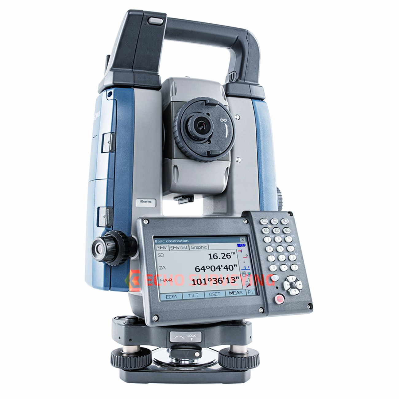
     Sokkia Robotic Total Station iX Series


    The ultimate total station 

    With the iX-1200/iX-600, you get the efficiency of a single-operator robotic system, the power of long-range reflectorless measurements, and the versatility of Hybrid Positioning™, all in your choice of 1”, 3” or 5” iX-1200 models or 2”, 3” or 5” iX-600 models.

     • 10 Hz update rates for faster more efficient staking

     • 150°/sec turning speed for exceptional productivity

     • 30% smaller and lighter than any other Sokkia series robotic instrument

     • Stay productive, stay confident with UltraTracTM prism lock technology

     • GNSS hybrid ready so you can handle any job site

     • Five-year UltraSonic motor warranty

     Ultra powerful

     Improved, intelligent Ultrasonic motor control provides smoother operation with less wear and tear. Ideal for survey or vertical construction, the solution is designed to stake or layout more points in less time even in challenging conditions.

    Ultra accurate

     UltraTrac™ prism tracking utilizes optical sensing combined with high-speed Ultrasonic motor control. Whether working at a distance or up close, the instrument maintains prism lock making you more productive in any environment.

     Ultra productive

     Combine and conquer with our hybrid solutions that utilize both GNSS and robotics so you can capture the shot, regardless of tree cover, loss of line of sight, or hard to reach points. Tackle any project in a fraction of the time. 


    • Fast and powerful EDM – 800 m (2,624 ft) non-prism and 6,000 m (19,685 ft) prism range
    • Rugged waterproof and dustproof IP65 design
    • Bright color touchscreen display for on-board data collection
    • Integrated Bluetooth® and advanced LongLink™ communication for up to 500 m (1,640 ft) fully robotic range
    • Direct Drive motors with a turning speed of 150º per-second
    • Advanced UltraTrac technology
    • Raised multi-key functionality
    • Add the RC-PR5A remote for up to 600 m (1,968 ft) “single tap” prism re-acquisition
    The bottom line is that a team equipped with a robotic total station can be five times as fast as team armed only with a set of drawings and a measuring tape.


    Workdays turned into workflows

     Bridge the gap between your mobile workforce and office staff with faster, more efficient cloud-based MAGNET® Enterprise services.

    • Use the Point Manager plug-in for Revit and AutoCAD for automated point creation
    • Secure connectivity to your active job sites as well as heavy machines using Sitelink3D™ 
    • Instant file sharing with both Autodesk® AutoCAD Civil 3D and Bentley MicroStation

    This information is taken http://global.topcon.com


    TOPCON GM-50

    Reflectorless Total Stations

    • Fast and accurate new EDM
    • Bluetooth® communications (optional)
    • Advanced angle accuracy
    • Long battery life – 14 hours
    • Rugged, waterproof design with IP66 rating
    • 500 m long-range reflectorless measurement
    • 50,000 point internal memory

    Topcon GM-50 Series total stations – advanced design with superior technology

    The GM-50 Series was designed from the ground up to deliver the very latest technological advantages, all in a small, sleek design you’ll appreciate the advantages from the very first measurement.


    Featuring a class leading EDM unit, the GM-50 is able to measure up to 4,000 m at 1.5 mm + 2 ppm accuracy, to standard prisms, and can measure in reflectorless mode up to 500 m at an incredible 2 mm + 2 ppm accuracy.


    Measurements are captured faster than ever, and with a beam width of 13 mm (at 30 m), the bright red laser dot pinpoints features with ease.


    Versatile, Economical Solution

    The GM-50 Series is smaller, lighter, with increased storage capacity. Offered at an even more cost-efficient option than previous models, it provides your customers the perfect tool for entry-level site layout and surveying.


    Bluetooth®    Communication

    With integrated Bluetooth® capability and internal antenna, the sleek design enables you to deliver measurements cable-free to your data controller.


    Tested for toughness

    We perform the tough environmental tests to ensure long-term operation even under the rough site environments. GM Series total stations are thoroughly inspected with dust-proof and water-proof test chambers. In addition, the various tests against vibration, drop, temperature, and humidity were successfully passed to achieve the best environmental spec. The measuring distance accuracy test on base line and the instrument leveling and angle accuracy test and adjustment by collimator system ensure your satisfaction on GM Series product quality.


    Ultra-powerful, advanced EDM

    500 m non-prism range

    4,000 m prism range

    Coaxial red laser pointer

    Pinpoint, precise beamspot


    Easy access USB 2.0 memory

    Up to 32GB storage

    Environmentally protected

    Compatible with industry standard thumb drives


    Advanced angle encoder system

    2” or 5” angle accuracy

    Incorporates exclusive IACS (Independent Angle Calibration System) on 2” and 5” models


    Rugged, waterproof design

    Waterproof/dustproof IP66 design handles the toughest environments

    Magnesium-alloy housing providing stable angle accuracy

    Graphic display and alphanumeric key board (standard)


    TOPCON GTL-1000


    TOPCON GTL-1000

    Construction Verification Every Day
      Quick layout and scanning with a single instrument
      Instant point cloud registration
      Proven robotic total station design integrated with a scanner
      Full dome scan and images in seconds
      Scan density tailored to minimize software processing time
      Accurately match point clouds to BIM coordinates


    The GTL-1000 will increase productivity on site by accelerating the construction process and identifying design challenges more efficiently than traditional methods… which will significantly benefit the industry as a whole; reducing  cost and program duration...


    Point Cloud Processing


    MAGNET® Collage and Collage Web

    Process, combine, and analyze 3D point clouds from the GTL-1000.

      Effortless point cloud registration process
      Web-based sharing of point clouds and meshes
      Faster processing with true GPU utilization
       •  Complete integration with construction verification workflows


    Construction Verification


    ClearEdge3D Verity for Navisworks®

    Verify construction quality in a fraction of the time by comparing as-built scans to BIM design and fabrication models.
      Reduce risks to budgets and schedules
      Clear indication of whether as-builts are within tolerance
      Increase project profitability by avoiding rework
      Fully integrated with Autodesk® Navisworks
      Quickly update coordination model to as-built conditions


    TOPCON MS AXII SERIES


    High Accuracy Measuring Station
    • Precise angle accuracies 0.5” (MS05AXII) and 1” (MS1AXII)
    • Auto-aiming accuracy of 1”
    • Remote control through on-line PC
    • Exclusive reflector prescan technology
    • Enforced durability for long term deformation and monitoring applications


    Rapid 2D Monitoring®


    In addition to natural hazards, such as harsh weather, soil movement or change of ground water level, engineering structures, such as buildings, dams, tunnels and bridges can always be affected by movement caused by excavation, heavy construction and piling placement. The MS Series provides superior measuring precision and is equipped with environmental protection and functions necessary in monitoring applications, allowing it to be utilized in a high-precision monitoring solution.

    Industrial measurement

    The MS05 AXII, when using reflective sheet targets, can achieve sub-millimeter accuracy allowing for measuring the shape and alignment of large-scale structures such as plants and bridges, as well as precise measurements of ships, railroad cars, and airplanes.

    First-order survey

    The MS Series offers high-precision angle accuracy (MS05 AXII: 0.5”, MS1 AXII: 1”) which can be used for a wide range of precise measurements. Equipped with an automatic tracking system, the high-precision robotic measuring station can be configured with a remote control system.

    Advanced auto-pointing algorithm for multiple prisms

    Incorporating an advanced auto-pointing algorithm*, optimized for monitoring applications, it automatically sights the prism closest to the telescope center regardless of the distance from the instrument. This works even if multiple prisms or other reflective objects are in the field of view, dramatically enhances the reliability in periodic monitoring of predetermined prism locations.

    Reflector prescan for monitoring setup

    The MS Series automatically searches within the predetermined area to quickly measure the reflectors as initial positions for subsequent routine measurements. This function works in low light or dark conditions where the reflectors cannot be clearly seen by the human eye.