Leica FlexLine TS10 Manual Total Station

 LEICA FLEXLINE TS10 MANUAL TOTAL STATION 

Work faster: 
  • Measure more points per day due to faster measurements and stakeout procedures, supported by the revolutionary Leica Captivate field software. The software is made to make your work easier and more enjoyable.
Use it trouble-free: 
  • Increase productivity and minimise downtime by relying on instruments that simply work and come with a global service and support network.


Choose products that are built to last: 
  • Even after years of use under harsh conditions (like mud, dust, blowing rain, extreme heat and cold), FlexLine still operates with the same high level of quality. 
Control your investment: 
  • Reliability, speed and accuracy ensure a lower investment over the product lifetime and a higher resell value.
Save time with AutoHeight: 

  • This revolutionary feature enables the FlexLine TS10 manual total station to automatically measure, read and set the instrument height. Errors are minimised and the setup process onsite is faster.


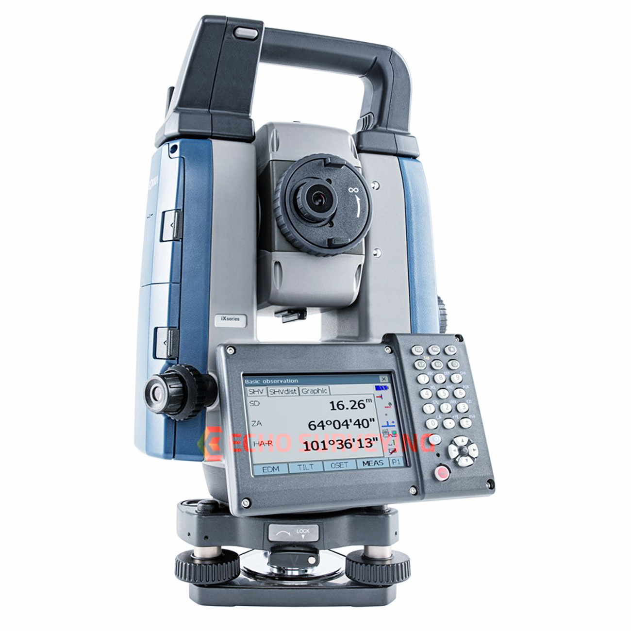
The Leica FlexLine TS10 manual total station combines user-friendly, ergonomic design with high-end reliability under harsh conditions. It enables you to tie into the modern 3D dataflow, including enhanced linework and coding. The TS10 offers mobile data device integration as an option. The larger, highly visible colour- and touchscreen helps you to complete your surveying tasks with the highest speed and accuracy. The new FlexLine generation of manual total stations relies on a proven product concept that has been revolutionising the world of measurement and survey for nearly 200 years.

This information is taken http://www.leica-geosystems.com

Current selling price 35.000 $


    Sokkia GRX3 Gnss Receiver


    Positioning made easy

    This fully integrated all-in-view constellation RTK GNSS receiver brings a new level of versatility and flexibility into your precision positioning applications. The GRX3 provides unmatched usability and versatility that’s sure to enhance your productivity.

    • And like all Sokkia products, you can customize it to meet your needs and create your own workflows.
    • Sokkia Tilt Technology
    • L Band Ready Technology
    • 226 Universal Tracking Channels™ covering all modernized signals (GPS, GLONASS, Galileo, BeiDou, IRNSS, QZSS, SBAS)
    • Integrated 400MHz UHF and SiteComm™ Radios
    • RTK and static survey operations
    • Fusion Positioning™ technology automated workflow
    • Standard RTK and Network RTK
    • IP67 rated


    Sokkia Tilt Technology

    The Sokkia GRX3 incorporates a revolutionary 9-axis inertial measurement unit (IMU) and an ultra-compact 3-axis eCompass. This advanced technology compensates for mis-leveled field measurements out of plumb by as much as 15 degrees. Awkward shots on steep slopes or hard to reach spots are now a breeze with tilt technology.

    Open Architecture

    The GRX3 architecture is designed so that third parties can write their own applications.

    All Constellation Support

    Featuring 226 Universal Tracking Channels with Universal Tracking Technology, the GRX3 has you covered. With programmable channels for tracking available signals, the GRX3 supports all modernized signals.

     Multiple Wireless Technologies

    The most commonly used wireless technologies can be integrated into the GRX3 receiver. Digital UHF, Network RTK and SiteComm™.

     Maximum Versatility

    Utilizing full wireless connectivity and no voice feedback, the GRX3 enables the use of both RTK and network RTK technologies. It can be operated as both a private RTK base and RTK rover using the internal digital UHF.

     Stay in Control

    The GRX3 includes built-in internal Bluetooth®  capability that allows you to choose your field controller model and software. Whether it is a small palm-sized screen device, a larger screen handheld, or even a field laptop, the GRX3 is ready to connect.

     Ready for the field

    The GRX3’s magnesium alloy body can handle even the toughest job site conditions. It’s compact, watertight, and rugged with IP67 rated dust and water protection.

    GeoPro Software

    This is the simplest, most effective software suite for the geomatics and survey professional.

     GeoPro Field

    Welcome to the quickest and easiest way to collect and layout points in the field. GeoPro Field’s user friendly interface and simple but powerful controls help you work faster and more precisely.

    • Graphical interface available on Windows®  tablets
    • Collect field measurements
    • Control GNSS and robotic systems from Sokkia
    • CAD in the field functionality
    • Export point files to 3rd party software


     GeoPro Office

    Process field measurement data from a variety of sensors in the same job file.

    By combining data from multiple sensors, you get a more complete view of the project than you would with separate static files from each sensor.

    • Process raw data from field measurements
    • Work with total station, digital level, and GNSS receiver data
    • GNSS post-processing
    • 3D CAD view (optional module)
    • Road design tools (optional module)


    Trimble SX12 Scanning Total Station


    KEY FEATURES

    Trimble® SX12 is the one instrument you need to handle any survey project by integrating surveying, imaging and 3D scanning capabilities into your everyday workflow.

    Integrated System

    • Collect survey data, VISION™ imagery, and high-speed scans easily with Trimble Access™ field software and the SX12’s Lightning 3DM
    • Process seamlessly with Trimble Business Center office software, or with Trimble RealWorks® Office Software for more advanced scan processing
    • Share with anyone using web-based Trimble Clarity
    • Rely on your equipment for years to come with the Trimble Service and Warranty guarantee


    Geomax Zoom95 Series

    Zoom95 Series 

    Zoom95 is the perfect one-person total station. 

    If you are in charge of surveying for construction projects or purchasing devices for your company, this one-person total station is made for you. The prism can be quickly located, tracked and stays locked with the built-in STReAM360 technology.

     Combined with our X-PAD field software, which is open to 3rdparty field controllers and available in Windows and Android, Zoom95 provides a full range of efficient choices. X-PAD software suite has been developed based on our customer feedback. It perfectly matches Zoom95 workflows. It is so easy to use that no extra training is needed.

     This solution is not only economical, with no maintenance cost, but your data is digitalised, secure and easy to access. 


    Modern data handling 

    ▪ Large 5″ VGA touch screen 

    ▪ Powerful processor - easy & fast handling of big files 

    ▪ Automatic data backup 

    ▪ Scout: Quick search for passive prisms within a large area


    Maximum flexibility 

    ▪ Field software: X-PAD Ultimate Survey or Build on Android, X-PAD Survey or Construction on Windows Mobile 

    ▪ Field controllers: GeoMax’ or your own device 


    Smart Investment 

    ▪ No maintenance cost for field software 

    ▪ Latest Hexagon technology 

    ▪ Stress-free equipment: PIN/ PUK – anti-theft feature


    ANGLE MEASUREMENTS

     Accuracy 1” (0.3 mgon), 2” (0.6 mgon), 3” (1.0 mgon), 5” (1.5mgon) 

    Display resolution 0.1” (0.1 mgon) 

    Method Absolute, continuous, diametrical 

    Compensation Quadruple axis 

    TELESCOPE

     Magnification 30x 

    DISTANCE MEASUREMENTS TO STD. PRISM ACCURACY/TIME (TYPICAL) 

    Single (fast) 2 mm + 1.5 ppm / 0.8s 

    Standard 1 mm + 1.5 ppm / 2.4s 

    Continuous 3 mm + 1.5 ppm / < 0.15s 

    Range up to 3500m 

    DISTANCE MEASUREMENTS - REFLECTORLESS

    Range accXess5 / accXXess10 500 m / 1000 m 

    Accuracy 2 mm + 2 ppm* 

    Time Typ. 2-6 sec 

    Precise capture 8x20 mm at 50 m 

    INTERFACE

     Keyboard Full alphanumeric; 25 keys; illuminated (2nd optional) 

    Display 5” WVGA 800x480 colour and touch with LED backlight 

    Data recording 2 GB internal memory; removable SD card and USB stick 

    Ports Serial; USB; internal Bluetooth®; long-range Bluetooth handle External power and WLAN 

    Operating system Microsoft® Windows® EC 7.0

    MOTORISATION 

    Technology Hybrid Drives 

    GeoTRAil - GNSS based prism search 

    Speed 100 g/sec 

    Scout - Opto-electronic prism search 

    Range 300 m at round prism 

    TRack - Automatic prism logging 

    Range 800 m at round prism 

    Max speed 90 km/h at 100m 

    AiM - Automatic prism fine aiming 

    Range 1,000 m at round prism 

    Hz/V accuracy 1” 

    Technique Image processing 

    NAVLIGHT ™ - ALIGNMENT AID 

    Range 5 m to 150 m 

    Accuracy 5 cm at 100 m 

    PHYSICAL SPECIFICATIONS 

    Weight 5.0 - 5.3 kg (w/o battery and tribrach) 

    Operating- / storage temperature -20° C to 50° C / -40° C to 70° C 

    Protection class IP55 dust and waterproof rating 

    Humidity 95%, non-condensing 

    POWER SUPPLY 

    Internal battery Removable Li-Ion 4.4 Ah / 7.4 V 

    Operating time Up to 8 h** 

    PLUMMET 

    Type Laser point, adjustable brightness 

    Accuracy 1.5 mm at 1.5 m instrument height 

    * > 500 m: 4 mm + 2 ppm; 

    ** Battery time may be shorter depending on conditions.


    This information is taken www.geomax-positioning.com


     Sokkia Robotic Total Station iX Series


    The ultimate total station 

    With the iX-1200/iX-600, you get the efficiency of a single-operator robotic system, the power of long-range reflectorless measurements, and the versatility of Hybrid Positioning™, all in your choice of 1”, 3” or 5” iX-1200 models or 2”, 3” or 5” iX-600 models.

     • 10 Hz update rates for faster more efficient staking

     • 150°/sec turning speed for exceptional productivity

     • 30% smaller and lighter than any other Sokkia series robotic instrument

     • Stay productive, stay confident with UltraTracTM prism lock technology

     • GNSS hybrid ready so you can handle any job site

     • Five-year UltraSonic motor warranty

     Ultra powerful

     Improved, intelligent Ultrasonic motor control provides smoother operation with less wear and tear. Ideal for survey or vertical construction, the solution is designed to stake or layout more points in less time even in challenging conditions.

    Ultra accurate

     UltraTrac™ prism tracking utilizes optical sensing combined with high-speed Ultrasonic motor control. Whether working at a distance or up close, the instrument maintains prism lock making you more productive in any environment.

     Ultra productive

     Combine and conquer with our hybrid solutions that utilize both GNSS and robotics so you can capture the shot, regardless of tree cover, loss of line of sight, or hard to reach points. Tackle any project in a fraction of the time. 


    • Fast and powerful EDM – 800 m (2,624 ft) non-prism and 6,000 m (19,685 ft) prism range
    • Rugged waterproof and dustproof IP65 design
    • Bright color touchscreen display for on-board data collection
    • Integrated Bluetooth® and advanced LongLink™ communication for up to 500 m (1,640 ft) fully robotic range
    • Direct Drive motors with a turning speed of 150º per-second
    • Advanced UltraTrac technology
    • Raised multi-key functionality
    • Add the RC-PR5A remote for up to 600 m (1,968 ft) “single tap” prism re-acquisition
    The bottom line is that a team equipped with a robotic total station can be five times as fast as team armed only with a set of drawings and a measuring tape.


    Workdays turned into workflows

     Bridge the gap between your mobile workforce and office staff with faster, more efficient cloud-based MAGNET® Enterprise services.

    • Use the Point Manager plug-in for Revit and AutoCAD for automated point creation
    • Secure connectivity to your active job sites as well as heavy machines using Sitelink3D™ 
    • Instant file sharing with both Autodesk® AutoCAD Civil 3D and Bentley MicroStation

    This information is taken http://global.topcon.com


    Leica GS18 T GNSS RTK

    Leica GS18 T – The world’s fastest GNSS RTK rover

    Introducing the world’s fastest and easiest-to-use GNSS RTK rover, the Leica GS18 T. Now you can measure any point faster and easier without the need to hold the pole vertical.

    This latest innovation combines GNSS and inertial measurement unit (IMU) being the first true tilt compensation solution that is immune to magnetic disturbances and is calibration-free. The GS18 T works directly out of the box.

    Save up to 20 per cent over conventional surveying practices due to the fact that no time is wasted by levelling the bubble.Focus on your surroundings and not the bubble to measure points that previously could not be measured. Avoid timeconsuming auxiliary methods with true tilt compensated surveying. You will stake out more efficiently and conveniently than ever before with increased speed, safety and comfort. Watching the bubble is simply no longer needed.

    The GS18 T GNSS RTK rover is part of the Leica Geosystems self-learning GNSS series. It seamlessly combines with Leica Captivate field software and Leica Infinity office software, continuing the powerful and immersive Leica Captivate Experience.


    Engaging software

    The Leica GS18 T is accompanied with the revolutionary Captivate software, turning complex data into
    the most realistic and workable 3D models. With easy-to-use apps and familiar touch technology, all forms of measured and design data can be viewed in all dimensions. Leica Captivate spans industries and applications with little more than a simple swipe, regardless of whether you work with GNSS, total stations or both.

    Seamlessly share data among all your instruments

    Leica Infinity imports and combines data from your GNSS RTK rover, total station and level instruments for one final and accurate result. Processing has never been made easier when all your
    instruments work in tandem to produce precise and actionable information.


    ACC

    Customer care only a click away Through Active Customer Care (ACC), a global network of  experienced professionals is only a click away to expertly guide you through any challenge. Eliminate delays with superior technical service, finish jobs faster and avoid costly site revisits with excellent consultancy support. Control your costs with a tailored Customer Care Package (CCP), giving you peace of mind you are covered anywhere, anytime.


    TILT COMPENSATION

    ■■ Increased measurement productivity and traceability
    ■■ Calibration-free
    ■■ Immune to magnetic disturbances
    ■■ Integrated quality assurance of pole tilt
    ■■ Reduction of human error

    RTKplus

    ■■ 555 channels for more signals, faster acquisition and
    improved sensitivity
    ■■ Intelligent management of multi-frequency, multiconstellation
    signals
    ■■ Intelligent selection to automatically reject reflected or
    noisy signals

    SMARTLINK
    ■■ Achieve centimetre accurate positioning worldwide -
    perfect when working in remote areas around the globe

    SMARTCHECK
    ■■ Unique RTK technology provides continuous checks to
    guarantee correct results
    ■■ Initialisation within seconds
    ■■ Complete reliability

    BUILT FOR THE MOST DEMANDING ENVIRONMENTS
    ■■ IP66 / IP68 protection
    ■■ Built for extreme temperatures of -40°C to +65°C
    ■■ Fulfils toughest standards throughout the complete
    product lifetime
    ■■ Rugged aluminium housing

    ERGONOMICS
    ■■ Integrated 4G mobile phone, UHF radio RTK devices
    ■■ Compact housing

    ONLINE SERVICES
    ■■ HxGN SmartNet Satellite Positioning - your No.1
    partner for network RTK
    ■■ Leica Active Assist - the next level in support
    ■■ Leica Exchange - transfer data easily, quickly and safely

    This information is taken http://www.leica-geosystems.com

    TOPCON GM-50

    Reflectorless Total Stations

    • Fast and accurate new EDM
    • Bluetooth® communications (optional)
    • Advanced angle accuracy
    • Long battery life – 14 hours
    • Rugged, waterproof design with IP66 rating
    • 500 m long-range reflectorless measurement
    • 50,000 point internal memory

    Topcon GM-50 Series total stations – advanced design with superior technology

    The GM-50 Series was designed from the ground up to deliver the very latest technological advantages, all in a small, sleek design you’ll appreciate the advantages from the very first measurement.


    Featuring a class leading EDM unit, the GM-50 is able to measure up to 4,000 m at 1.5 mm + 2 ppm accuracy, to standard prisms, and can measure in reflectorless mode up to 500 m at an incredible 2 mm + 2 ppm accuracy.


    Measurements are captured faster than ever, and with a beam width of 13 mm (at 30 m), the bright red laser dot pinpoints features with ease.


    Versatile, Economical Solution

    The GM-50 Series is smaller, lighter, with increased storage capacity. Offered at an even more cost-efficient option than previous models, it provides your customers the perfect tool for entry-level site layout and surveying.


    Bluetooth®    Communication

    With integrated Bluetooth® capability and internal antenna, the sleek design enables you to deliver measurements cable-free to your data controller.


    Tested for toughness

    We perform the tough environmental tests to ensure long-term operation even under the rough site environments. GM Series total stations are thoroughly inspected with dust-proof and water-proof test chambers. In addition, the various tests against vibration, drop, temperature, and humidity were successfully passed to achieve the best environmental spec. The measuring distance accuracy test on base line and the instrument leveling and angle accuracy test and adjustment by collimator system ensure your satisfaction on GM Series product quality.


    Ultra-powerful, advanced EDM

    500 m non-prism range

    4,000 m prism range

    Coaxial red laser pointer

    Pinpoint, precise beamspot


    Easy access USB 2.0 memory

    Up to 32GB storage

    Environmentally protected

    Compatible with industry standard thumb drives


    Advanced angle encoder system

    2” or 5” angle accuracy

    Incorporates exclusive IACS (Independent Angle Calibration System) on 2” and 5” models


    Rugged, waterproof design

    Waterproof/dustproof IP66 design handles the toughest environments

    Magnesium-alloy housing providing stable angle accuracy

    Graphic display and alphanumeric key board (standard)


    Leica BLK360 Imaging Laser Scanner

    The Leica BLK360 captures the world around you with full-colour panoramic images overlaid on a high-accuracy point cloud. Simple to use with the single push of one button, the BLK360 is the smallest and lightest imaging laser scanner of its kind. Anyone who can operate an iPad can now capture the world around them with high resolution 3D panoramic images.

    Using Leica Cyclone FİELD 360 mobile-device app, the BLK360 streams image and point cloud data to an iPad or final project data to Cyclone REGISTER 360 or Cyclone REGISTER 360 (BLK Edition) via Wi-Fi. With automated workflows in both software offerings, the BLK360 plus the software solution of your choice, dramatically streamlines the reality capture process thereby opening this technology to non-surveying individuals. Simple export of LGS or RCP files makes working with point cloud data downstream in the Leica Geosystems and Autodesk suites simple and efficient, allowing users to spend less time processing data and more time creating meaningful deliverables.


    BLK360 imaging laser scanner

    • Allows you to scan in high, standard and fast resolutions
    • Weighs 1 kg / Size 165 mm tall x 100 mm diameter
    • Less than 3 minutes for full-dome scan (in standard resolution) and 150 MP spherical image generation
    • 360,000 laser scan setpoints per second
    • High-Dynamic Range (HDR) and thermal imaging

    Software offerings to meet your needs

    • Upgrade your subscription to Cyclone REGISTER 360 for users who want to take on mid-to-large scale projects involving additional data sources
    • Bundled with Leica Geosystems’ next generation of registration software, Cyclone REGISTER 360 for users who want to take on mid-to-large scale projects
    • Operate the BLK360 to automatically capture, register and examine scan and image data, directly within the Cyclone FIELD 360 app from any iOS or Android mobile-device
    • Directly publish your captured data from Cyclone FIELD 360 to Leica TruView Cloud to quickly exchange project information prior to import and registration

    Speed


    On-the-fly image and point cloud processing in the field and auto-registration office workflows with Cyclone REGISTER 360 and Cyclone REGISTER 360 (BLK Edition).

    Portability


    Flexibility to scan wherever, whenever with the small, lightweight imaging laser scanner that fits into a messenger bag.

    Ease-of-use


    Push-button scanning that automatically stitches and registers captured scan data for in-field visualisation in the mobile version of Cyclone FIELD 360, transferring seamlessly to Cyclone REGISTER 360 or Cyclone REGISTER 360 (BLK Edition) via Wi-Fi for final processing.

    Cloud connectivity


    Better collaboration and virtualisation with cloud sync.

    Simplified data collection


    Two-in-one 360º image documentation and laser scan data.

    Interoperability


    Fully compatible with the Leica Geosystems laser scanning field-to-finished software suite.

    This information is taken http://www.leica-geosystems.com


    TOPCON GTL-1000


    TOPCON GTL-1000

    Construction Verification Every Day
      Quick layout and scanning with a single instrument
      Instant point cloud registration
      Proven robotic total station design integrated with a scanner
      Full dome scan and images in seconds
      Scan density tailored to minimize software processing time
      Accurately match point clouds to BIM coordinates


    The GTL-1000 will increase productivity on site by accelerating the construction process and identifying design challenges more efficiently than traditional methods… which will significantly benefit the industry as a whole; reducing  cost and program duration...


    Point Cloud Processing


    MAGNET® Collage and Collage Web

    Process, combine, and analyze 3D point clouds from the GTL-1000.

      Effortless point cloud registration process
      Web-based sharing of point clouds and meshes
      Faster processing with true GPU utilization
       •  Complete integration with construction verification workflows


    Construction Verification


    ClearEdge3D Verity for Navisworks®

    Verify construction quality in a fraction of the time by comparing as-built scans to BIM design and fabrication models.
      Reduce risks to budgets and schedules
      Clear indication of whether as-builts are within tolerance
      Increase project profitability by avoiding rework
      Fully integrated with Autodesk® Navisworks
      Quickly update coordination model to as-built conditions