
Satlab SL600 GNSS Receiver
Satlab SL600 6G GNSS Receiver
The Ultimate On The Pole GNSS System With 6G Tracking

All in one, on the pole GNSS Receiver
Intelligent System
The Ultimate On The Pole GNSS System With 6G Tracking
All in one, on the pole GNSS Receiver
Intelligent System
Leica TS 06 Plus
Leica FlexLine TS06plus
Top Precision meets
High Efficiency

Top Precision meets
High Efficiency
For most, “quality” is relative. Not so at Leica Geosystems. To ensure our instruments meet the highest precision and quality requirements, we manufacture them in state-of-the-art facilities around the world. Swiss technology combines with exceptional craftsmanship to provide best-in-class devices. And this quality also applies to all of our procedures – moving Leica Geosystems towards business excellence to meet our customers’ needs and expectations in every way. The Leica FlexLine TS06plus Manual Total Station is ideal for many daily surveying tasks, especially for mid- to high-accuracy applications. Banking on the heritage of the previous Leica TS06 model, the most successful of the Leica FlexLine Series, the Leica FlexLine TS06plus is the newest ultimate Total Station. Welcome to the world of Leica Geosystems. Welcome to a world of people, technologies, services and devices, that you can completely rely on.
Sokkia SDL 30/50
Sokkia SDL30/SDL50 Digital Levels
Save Time with Innovative, Industry-Leading Technologies

2.5-second High-speed Measurement, 20 lux Minimum Brightness, Inverted Staff Recognition, Wave-and-Read, and the Highest Accuracy in its Class.
2.5 seconds – High-speed Measurement
Aim, focus, and press a key. Height and distance are simultaneously measured in 2.5 seconds, 20 percent faster than ordinary digital levels.
Consistent Performance in Diverse Environments
Leica Builder Series
 Whether you have to precisely layout a construction site, performcontrol measurements, collect height and angle data, align concrete forms, install ceilings and partitions, lay gravity flow pipe, locate underground services or complete site preparation and earthworks Leica Geosystems offers the right instrument, construction laser or machine control installation specifically designed for your construction application.
Easy-to-use, jobsite tough, accurate and reliable Leica Geosystems instruments and lasers ensure the efficient use of your materials and resources. High quality products, such as optical and electronic levels, construction lasers, total stations and machine automation systems, provide fast results, keep you working and increase your profitability. When it has to be right.
Nikon C Series Total Station
Nikon Nivo™ C Series
Specifications:

■ 1”, 2”, 3” and 5” angle accuracies
■ Survey Pro, Survey Basic with Roads and Layout Pro software
■ Prism and reflectorless modes
■ Long-lasting, hot swappable batteries
■ Laser pointer
■ Optional laser plummet
■ Windows CE color touch screen
■ Bluetooth
Specifications:
■ 1”, 2”, 3” and 5” angle accuracies
■ Survey Pro, Survey Basic with Roads and Layout Pro software
■ Prism and reflectorless modes
■ Long-lasting, hot swappable batteries
■ Laser pointer
■ Optional laser plummet
■ Windows CE color touch screen
■ Bluetooth
Trimble GNSS Surveying Systems
TRIMBLE GNSS SYSTEMS: SOLVING YOUR CHALLENGES IN THE FIELD
 INDUSTRY-LEADING GNSS SOLUTIONS DESIGNED WITH THE SURVEYOR IN MIND
INDUSTRY-LEADING GNSS SOLUTIONS DESIGNED WITH THE SURVEYOR IN MIND
Backed by a legacy of GNSS technology and surveying expertise, Trimble provides surveyors with reliable GNSS survey solutions that meet their distinct requirements. For more than 30 years, Trimble
has been setting the standard when it comes to positioning technology—and that tradition continues today and into the future.
Topcon GLS-2000 Laser Scanner
Compact High-Speed Laser Scanner

• Highest Accuracy with Precise Scan Technology
• High Speed 360º Dome Scanning
• Long Range
• Dual Camera
• Eye Safe - Selectable Laser Technology
• Compact, Lightweight Rugged Design
• Highest Accuracy with Precise Scan Technology
• High Speed 360º Dome Scanning
• Long Range
• Dual Camera
• Eye Safe - Selectable Laser Technology
• Compact, Lightweight Rugged Design
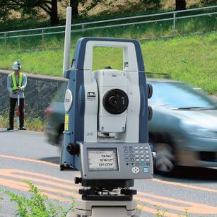
Sokkia DX Series
Direct Aiming X-ellence Station
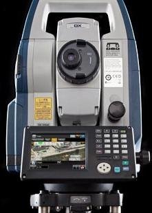
• Upgradable Auto-Tracking Technology
• Advanced Angle Measurement System
• RED-tech Technology Reflectorless EDM
• LongRange Data Communication
• MAGNET™ Field On-board Software
New Auto Pointing “Direct Aiming Technology”
• Upgradable Auto-Tracking Technology
• Advanced Angle Measurement System
• RED-tech Technology Reflectorless EDM
• LongRange Data Communication
• MAGNET™ Field On-board Software
New Auto Pointing “Direct Aiming Technology”
The DX Series employs “Direct Aiming Technology” featuring a new intelligent algorithm that automatically aims to the prisms with precisely corrected angle readings. The technology works even in dim or dark conditions where the prism is difficult to be found. Whatever the job requires and wherever operators must go, the DX Series gets your job done faster and easier while still maintaining high accuracy.
Geomax Zoom 80
Robotic Total Station Zoom80 Series

STReAM360
• Scout – Auto Find
• TR ack – Auto Tracking
• AiM – Auto Targeting
Long Range Bluetooth
• High-Speed Data Link
• Reliable Connectivity
• License Free
Powerful Handheld
• Inbuilt Camera (5M Pixel)
• Compass & Altimeter
• Long-range Bluetooth®

STReAM360
• Scout – Auto Find
• TR ack – Auto Tracking
• AiM – Auto Targeting
Long Range Bluetooth
• High-Speed Data Link
• Reliable Connectivity
• License Free
Powerful Handheld
• Inbuilt Camera (5M Pixel)
• Compass & Altimeter
• Long-range Bluetooth®
Leica FlexLine TS09plus
Full Precision at High Performance
 For most, “quality” is relative. Not so at Leica Geosystems. To ensure our instruments meet the highest precision and quality requirements, we manufacture them in state-of-theart facilities around the world. Swiss technology combines with exceptional craftsmanship to provide best-in-class devices. And this quality also applies to all of our procedures – moving Leica Geosystems towards business excellence to meet our customers’ needs and expectations in every way. The Leica FlexLine TS09plus Manual Total Station is ideal for mid- to high-accuracy applications. The brilliant color display with touch operation, built-in Bluetooth®, USB host and device board offer the highest performance and ease of use. Welcome to the world of Leica Geosystems. Welcome to a world of people, technologies, services and devices that you can completely rely on.
For most, “quality” is relative. Not so at Leica Geosystems. To ensure our instruments meet the highest precision and quality requirements, we manufacture them in state-of-theart facilities around the world. Swiss technology combines with exceptional craftsmanship to provide best-in-class devices. And this quality also applies to all of our procedures – moving Leica Geosystems towards business excellence to meet our customers’ needs and expectations in every way. The Leica FlexLine TS09plus Manual Total Station is ideal for mid- to high-accuracy applications. The brilliant color display with touch operation, built-in Bluetooth®, USB host and device board offer the highest performance and ease of use. Welcome to the world of Leica Geosystems. Welcome to a world of people, technologies, services and devices that you can completely rely on.
Full Precision, Superior Convenience and Performance
Electronic Distance Measurement:
Topcon GR-5 Advanced GNSS Receiver

• G3 Tracking Technology (GPS/GLONASS/Galileo)
• Advanced Fence Antenna™ Technology
• High accuracy RTK up to 100Hz
• Integrated dual radio and cellular combinations
The GR-5 is the most advanced RTK GPS system from Topcon. This exciting system incorporates G3 tracking technology to track all three satellite positioning systems as well as new design features not found in any other system.
Topcon’s G3 technology was the first to combine all three of the original positioning systems – GPS, GLONASS, and Galileo. Although commercial use of Galileo continues to be years away, Topcon continues its commitment to develop technology to utilize ALL signals from ALL satellites. Not only is Topcon committed to the GPS, GLONASS and Galileo satellite systems, but also to all precision signals from the developing Chinese COMPASS system, Japan’s Quasi-Zenith Satellite System (QZSS), and India’s IRNSS system. If there is any operational advantage of combining new systems and signals, you can count on Topcon to continue to lead the industry.
Sokkia GRX2 GNSS Receiver
 Sokkia GRX2 has been enhanced with the latest GNSS chipset technology, providing 226 channels
and superior antenna quality. Both RTK and Static operations will be completed with increased productivity. The GRX2 provides unmatched usability and versatility that guarantees to increase productivity.
GRX2 GNSS Receiver
The GRX2 receiver is a fully integrated dual constellation receiver, antenna, radio, and optional cellular modem. In addition, the integrated Bluetooth® module, now enhanced for better performance, is designed into a rugged magnesium alloy body.
Fully Scalable Architecture
Pentax S-2100
System description
The PENTAX Scanning System S-2100 has a 360° vertical field of view and is the fastest 2D laser measurement system in the world. With its scan rate of more than 1 million points per second and a maximum scan speed of 200 profiles / sec., very short distances between profiles can be achieved even at high speeds. The high point density ensures that even the smallest objects can be registered and processed by the software. The new laser measurement system is classified “eyesafe” in laser class 1. The scanner can be used in urban environments without any restrictions. A hardware-assisted pixel-by-pixel synchronization, already used and tested in previous models, makes it possible to process external signals to determine the position of the scan data.
Pentax R-400 VDN
Capture the full picture


- 400m reflectorlessEDM range
- Effective 3.1 MP camera
- Easy transfer to a PC via USB, SD connection
- Dual axis compensator 3” and 5” models
- Adjustable laser plummet
2= 1 Dual function Communicate and collaborate without ambiguity
Data measurements can be misinterpreted by anyone, from office team members to clients. And changes due to poor communication become exponentially more expensive with each step in the project’s development. The R-400VDN total station combines a non-prism total station with an advanced 3.1-megapixel digital camera, enabling you to visualise the points measured. Detailed pictures made with the Pentax Visio Total Station enable all to accurately review the actual situation at the time of measurement – helping catch possible mistakes in the process. Detailed pictures rovide immediate visual feedback.
Topcon IS Series
Advanced Imaging Technology
- Twin Digital Cameras – Wide Angle and 30x optical zoom TTL
- Intelligent Image Scanning
- XTRAC8 Auto-Tracking
- 2000m reflectorless measurement
- Long range live video instrument control

Imagine the power, accuracy and speed of the proven Topcon QS-A robotic series, give it faster scanning capability and 2 cameras, and you have the IS-3. Advanced imaging and high-accuracy surveying techniques are combined in a single innovative instrument.
How it works:
Topcon’s IS combines our proven robotic technology with dual digital Imaging cameras to provide a
full colour, real-time image on a touch sensitive LCD display. View your data in real time and utilise the iSCAN options for thorough data collection. Select one of these routines to automatically measure feature points, cross sections or regular grids of points.
Point selection - as precisely as you need.
Thanks to digital imaging using our coaxial Through The Lens (TTL) camera, you can be confident that the point you select on the screen and measure is the point you need! Navigate your site with the
wide-angle camera and zoom to pinpoint features which can be measured up to 2000m away. This
can be carried out on the IS-3, or remotely on our field controllers, using the new WT-100, controlling the instrument by live video feed up to an amazing 300m away.
Leica Nova MS50
The new dimension in measuring technology.
Abstract
Outstanding and enhanced total station functionality, GNSS connectivity, high resolution digital imaging and 3D laser scanning; this is mergeTEC a key component of the Leica Nova MS50.
mergeTEC not only merges the technologies it also merges the data. Images are referenced to total station measurements, total station measurements are complemented by 3D point clouds, which, themselves are colored by the image information. All data perfectly fits within the same coordinate system, globally referenced by GNSS measurements or by measuring known points.
How the Leica Nova MS50 – the world’s first MultiStation – can combine total station functionality,
GNSS connectivity, digital imaging and 3D laser scanning in a single instrument and how the separate sensors work will be presented in this white paper.

Introduction
Leica Nova MS50 embodies 90 years of innovative thinking of Leica Geosystems to develop precise, reliable and flexible technologies.
Trimble S8
THE POWER TO EXCEL

Delivering major workflow innovations for both typical surveying and specialized applications, you
now have the power to redefine your performance potential.

Delivering major workflow innovations for both typical surveying and specialized applications, you
now have the power to redefine your performance potential.
ADVANCED SURVEYING PERFORMANCE
For typical survey tasks, choose the 1" angle accuracy and exceptional EDM range of Trimble DR Plus™. Extend your reach on the job for increased production from fewer setups. Trimble Business Center office software provides a complete range of processing and analysis tools. Together with the Trimble S8, you have the most comprehensive solution for general surveying available today.
TOPCON PS Series
Topcon Robotic Total Stations
- Advanced security and maintenance with new TSshield™
- PowerTrac™ tracking
- Ultra-powerful advanced EDM
- Exclusive LongLink™ communications
- Advanced angle accuracy
- Rugged, waterproof design

Advanced Design with Superior Technology
The PS is a professional grade robotic total station. This new advanced design provides an onboard data collection interface, exclusive LongLink™ communication, and an incredibly powerful EDM.
LEICA TS 30
 The new Leica TS30 total station is unique. This new total station has redefi ned precise surveying by offering unmatched accuracy and quality. Never again will surveyors with demanding tasks need to make compromises, the TS30 total station is ready for any challenge.
It all started more than 75 years ago with the Wild T3 precision theodolite that stunned the surveying community with highly accurate measurements. Now, four generations later, Leica Geosystems continues to build on the values of accuracy and quality. The latest generation of Champions, the Leica TS30 total station has reached the pinnacle. Generations of surveyors
have trusted in accuracy and quality from Leica Geosystems, now it’s time to take this trust to the next level.
SOKKIA SX SERIES
Sokkia SX Series Precision Robotic Total Station
The New Definition of Robotics
Extremely Accurate Auto-Tracking
Incorporating the industry’s most advanced laser and image processing technologies, the SX offers market leading prism tracking capability and enhanced prediction of prism movement. The SX accurately locks and tracks a moving prism In any jobsite environment.
Waterproof, Rugged, and Operator Friendly
MAGNET™ Field On-Board Application Software
RED-tech Technology Reflectorless EDM
Subscribe to:
Posts (Atom)